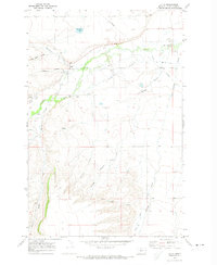
1970 Map of Utica
USGS Topo · Published 1973About this map
The settlement of Utica serves as the focal point of this Central Montana landscape, situated near the confluence of Courtneys Creek and the Judith River. Photogrammetric data from 1968 and a 1970 field check reveal a region defined by complex drainage patterns, with numerous coulees such as Heiserman Coulee, Coal Bank Coulee, and Ellis Coulee cutting through the terrain. To the south, the topography rises toward Rosman, while the Ackley Lake Feeder Canal in the northeast indicates the importance of water management for local agriculture.
Find a feature on this map
19 named features on this map. Tap any name to fly to it.
Don’t see what you’re looking for? This feature index may not catch every label — zoom into the map to look around manually.
Map Details
Editions of this 1970 Utica Map
This is the sole edition of this map. No revisions or reprints were ever made.
Other maps of this area

1886 · Little Belt Mts.
USGS Topo · 1:250,000

1889 · Big Snowy Mountain
USGS Topo · 1:250,000

1890 · Fort Benton
USGS Topo · 1:250,000

1892 · Fort Benton
USGS Topo · 1:250,000

1893 · Big Snowy Mountain
USGS Topo · 1:250,000

1894 · Little Belt Mts.
USGS Topo · 1:250,000

1897 · Fort Benton
USGS Topo · 1:250,000

1897 · Little Belt Mts.
USGS Topo · 1:250,000

1898 · Little Belt Mts.
USGS Topo · 1:250,000

1902 · Little Belt Mts.
USGS Topo · 1:250,000