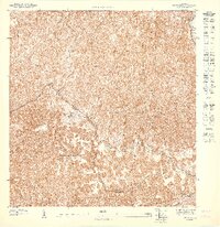
1947 Map of Utuado NO
USGS Topo · Published 1947About this map
The boundary between Municipio Arecibo and Municipio Utuado winds through this 1940s topographic study, characterized by the intricate drainage systems of the Rio Grande De Arecibo and the Rio Tanamá. This preliminary map, published by the U.S. Geological Survey based on 1943 data, details a landscape of extreme relief before major modern development. The northern portions are dominated by the Bosque Estatal De Rio Abajo, revealing the dense network of ridges and depressions that defined this forest preserve. Human presence is marked by small structures and rural landmarks like the Iglesia San Pascual, while the intricate contour lines illustrate the karst topography unique to this region of northern Puerto Rico.
Find a feature on this map
5 named features on this map. Tap any name to fly to it.
Don’t see what you’re looking for? This feature index may not catch every label — zoom into the map to look around manually.
Map Details
Editions of this 1947 Utuado NO Map
This is the sole edition of this map. No revisions or reprints were ever made.
Other maps of this area

1938 · Camuy
USGS Topo · 1:20,000

1942 · Arecibo
USGS Topo · 1:30,000

1942 · Camuy
USGS Topo · 1:30,000

1943 · Utuado NE
USGS Topo · 1:10,000

1946 · Utuado
USGS Topo · 1:30,000

1946 · Bayaney
USGS Topo · 1:30,000

1946 · Arecibo
USGS Topo · 1:30,000
1947 · Utuado SE
USGS Topo · 1:10,000
1947 · Arecibo SO
USGS Topo · 1:10,000
1947 · Utuado SO
USGS Topo · 1:10,000