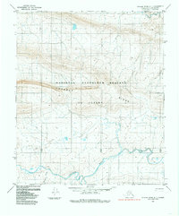
1984 Map of Utukok River A-1
USGS Topo · Published 1985About this map
Lookout Ridge dominates the central landscape of this North Slope survey, where the vast, unpopulated terrain of the National Petroleum Reserve in Alaska is meticulously documented. The hydrology of the region is defined by the braided path of the Colville River in the south and Carbon Creek to the north. These waterways serve as the primary landmarks in a territory characterized by complex contour elevations and seasonal wetlands. Evidence of human presence is sparse, appearing only as a solitary Trail crossing the northern tundra, underscoring the remoteness of the region during the early 1980s. The map illustrates the administrative transition between township and range lines across a landscape that remains primarily shaped by the flow of Reynard Creek and other glacial tributaries.
Find a feature on this map
13 named features on this map. Tap any name to fly to it.
Don’t see what you’re looking for? This feature index may not catch every label — zoom into the map to look around manually.
Map Details
Editions of this 1984 Utukok River A-1 Map
This is the sole edition of this map. No revisions or reprints were ever made.
Other maps of this area

1951 · Utukok River
USGS Topo · 1:250,000

1951 · Lookout Ridge
USGS Topo · 1:250,000

1951 · Howard Pass
USGS Topo · 1:250,000

1951 · Misheguk Mountain
USGS Topo · 1:250,000

1956 · Lookout Ridge
USGS Topo · 1:250,000

1956 · Howard Pass
USGS Topo · 1:250,000

1956 · Misheguk Mountain
USGS Topo · 1:250,000

1956 · Utukok River
USGS Topo · 1:250,000

1965 · Utukok River
USGS Topo · 1:250,000
1984 · Howard Pass D-5
USGS Topo · 1:63,360