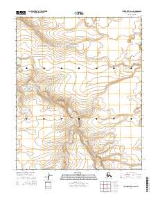
2014 Map of Utukok River D-2 NE
USGS Topo · Published 2014About this map
The Omikmuktusuk River carves a winding path through the North Slope landscape in this 2014 survey. Flowing across the central and southern portions of the quadrangle, this waterway is the primary drainage feature for the surrounding terrain. The map details the precise township and range divisions, including t7n r32w and t7n r31w, which provide a formal grid over the remote Arctic wilderness. This document captures the topographical character of the region just before the mid-2010s, showing the intricate contour patterns that define the river valley and its adjacent uplands. It serves as a clear record of the hydrography and public land survey system in this specific corner of the North Slope Borough.
Find a feature on this map
7 named features on this map. Tap any name to fly to it.
Don’t see what you’re looking for? This feature index may not catch every label — zoom into the map to look around manually.
Map Details
Editions of this 2014 Utukok River D-2 NE Map
This is the sole edition of this map. No revisions or reprints were ever made.
Other maps of this area

1951 · Utukok River
USGS Topo · 1:250,000

1951 · Wainwright
USGS Topo · 1:250,000

1955 · Wainwright
USGS Topo · 1:250,000

1955 · Wainwright A-2
USGS Topo · 1:63,360
1955 · Wainwright A-1
USGS Topo · 1:63,360

1956 · Utukok River
USGS Topo · 1:250,000

1964 · Wainwright
USGS Topo · 1:250,000

1965 · Utukok River
USGS Topo · 1:250,000
1984 · Utukok River D-2
USGS Topo · 1:63,360
1984 · Utukok River D-1
USGS Topo · 1:63,360