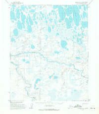
1955 Map of Wainwright A-1
USGS Topo · Published 1971About this map
Avalik River and the Ketik River converge amidst a landscape defined by meandering watercourses and seasonal routes in this mid-century survey of the North Slope. The presence of the Reindeer Service USDI Cabins (abandoned) near the Avalitkok Creek junction provides a specific historical marker of government-managed land use in the Arctic. Several segments of Winter Trail cross the terrain, illustrating the cold-weather transportation network required to navigate between water bodies like Takrak Lake and drainage systems including Irak Creek and Oyagaruk Creek. These trails and cabins reflect a period of administrative and logistical activity within what was then Naval Petroleum Reserve No. 4, offering researchers a detailed look at the infrastructure that supported remote operations before later developments transformed the region's accessibility.
Find a feature on this map
9 named features on this map. Tap any name to fly to it.
Don’t see what you’re looking for? This feature index may not catch every label — zoom into the map to look around manually.
Map Details
Editions of this 1955 Wainwright A-1 Map
2 editions found
Other maps of this area

1951 · Utukok River
USGS Topo · 1:250,000

1951 · Meade River
USGS Topo · 1:250,000

1951 · Wainwright
USGS Topo · 1:250,000

1951 · Lookout Ridge
USGS Topo · 1:250,000

1955 · Wainwright
USGS Topo · 1:250,000

1955 · Wainwright A-2
USGS Topo · 1:63,360

1955 · Wainwright B-1
USGS Topo · 1:63,360

1955 · Meade River
USGS Topo · 1:250,000
1955 · Meade River A-5
USGS Topo · 1:63,360
1955 · Meade River B-5
USGS Topo · 1:63,360