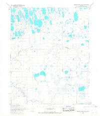
1955 Map of Meade River A-5
USGS Topo · Published 1967About this map
Naval Petroleum Reserve No. 4 defines this Arctic landscape during the mid-1950s, a period characterized by strategic exploration in the far north. The terrain is dominated by a complex network of thaw lakes and waterways, most notably the winding Avalik River and its tributary, Avalitkok Creek. Surveyed by the Army Map Service, the map highlights the utilitarian transport methods of the era, recording a Winter Trail and several Tractor Trails that provided the only overland access across the marshy tundra. These markings indicate the specific routes used for heavy equipment transport and seasonal supply lines before permanent infrastructure reached this part of the North Slope.
Find a feature on this map
9 named features on this map. Tap any name to fly to it.
Don’t see what you’re looking for? This feature index may not catch every label — zoom into the map to look around manually.
Map Details
Editions of this 1955 Meade River A-5 Map
2 editions found
Other maps of this area

1951 · Utukok River
USGS Topo · 1:250,000

1951 · Meade River
USGS Topo · 1:250,000

1951 · Wainwright
USGS Topo · 1:250,000

1951 · Lookout Ridge
USGS Topo · 1:250,000

1955 · Wainwright
USGS Topo · 1:250,000

1955 · Wainwright B-1
USGS Topo · 1:63,360

1955 · Meade River
USGS Topo · 1:250,000
1955 · Meade River A-4
USGS Topo · 1:63,360

1955 · Meade River B-4
USGS Topo · 1:63,360
1955 · Meade River B-5
USGS Topo · 1:63,360