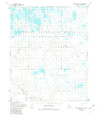
1955 Map of Meade River A-5
USGS Topo · Published 1982About this map
The National Petroleum Reserve in Alaska dominates this 1955 survey of the North Slope, revealing a landscape defined by its remote industrial and transport corridors. The map records a critical era of Arctic exploration, tracing the Winter Trail and several instances of the Tractor Trail crossing the tundra. These routes were essential for seasonal movement across the frozen terrain before more permanent infrastructure existed. In the southern portion of the quadrangle, the Avalik River and its tributary, Avalitkok Creek, meander through a dense network of lakes and marshes. Named topographic points such as Lambda, Kappa, and Gamma appear as distinct markers in an otherwise largely uniform landscape, likely serving as vital survey stations or navigation landmarks for the Army Map Service and other agencies operating in the North Slope Borough.
Find a feature on this map
16 named features on this map. Tap any name to fly to it.
Don’t see what you’re looking for? This feature index may not catch every label — zoom into the map to look around manually.
Map Details
Editions of this 1955 Meade River A-5 Map
2 editions found
Other maps of this area

1951 · Utukok River
USGS Topo · 1:250,000

1951 · Meade River
USGS Topo · 1:250,000

1951 · Wainwright
USGS Topo · 1:250,000

1951 · Lookout Ridge
USGS Topo · 1:250,000

1955 · Wainwright
USGS Topo · 1:250,000

1955 · Wainwright B-1
USGS Topo · 1:63,360

1955 · Meade River
USGS Topo · 1:250,000
1955 · Meade River A-4
USGS Topo · 1:63,360
1955 · Meade River A-5
USGS Topo · 1:63,360

1955 · Meade River B-4
USGS Topo · 1:63,360