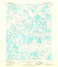
1955 Map of Meade River B-5
USGS Topo · Published 1967About this map
Naval Petroleum Reserve No. 4 encompasses this entire expanse of the North Slope, where a complex network of thousands of oriented thaw lakes dominates the permafrost landscape. The hydrology is defined by the winding course of Kolipsun Creek, which meanders through a dense cluster of water bodies and marshy lowlands. Human presence is evidenced primarily by transportation corridors, specifically a network of seasonal routes including a designated Winter Trail and several other segments labeled simply as Trail. These paths represent the essential overland connections across the tundra before modern infrastructure. The map reflects a mid-century period of federal land management and strategic energy exploration, captured through photogrammetric aerial surveys that reveal the intricate, lace-like patterns of the Arctic coastal plain.
Find a feature on this map
4 named features on this map. Tap any name to fly to it.
Don’t see what you’re looking for? This feature index may not catch every label — zoom into the map to look around manually.
Map Details
Editions of this 1955 Meade River B-5 Map
This is the sole edition of this map. No revisions or reprints were ever made.
Other maps of this area

1951 · Meade River
USGS Topo · 1:250,000

1951 · Wainwright
USGS Topo · 1:250,000

1955 · Wainwright
USGS Topo · 1:250,000

1955 · Wainwright B-1
USGS Topo · 1:63,360

1955 · Meade River
USGS Topo · 1:250,000

1955 · Wainwright C-1
USGS Topo · 1:63,360
1955 · Meade River A-4
USGS Topo · 1:63,360
1955 · Meade River A-5
USGS Topo · 1:63,360

1955 · Meade River C-5
USGS Topo · 1:63,360

1955 · Meade River B-4
USGS Topo · 1:63,360