
1955 Map of Wainwright C-1
USGS Topo · Published 1967About this map
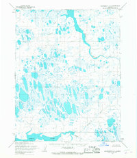
The Naval Petroleum Reserve No. 4 encompasses this entire Arctic landscape, defined by a dense concentration of thaw lakes and meandering watercourses characteristic of the North Slope. The Kugrua River dominates the northern reaches, while the Kungok River flows through the southern terrain, joined by the waters of Kolipsum. This 1955 survey illustrates the remote wilderness during a period of federal geographic evaluation, long before modern infrastructure reached this part of Alaska. Avgumun Creek weaves through the western sections, dotted with numerous unnamed ponds and tundra pools. The site of Casey stands as a solitary named point in the northwest, offering a rare human landmark in a region otherwise shaped by permafrost and drainage patterns. The lack of roads or trails on the sheet reflects the isolation of the territory at mid-century.
Find a feature on this map
7 named features on this map. Tap any name to fly to it.
Don’t see what you’re looking for? This feature index may not catch every label — zoom into the map to look around manually.
Map Details
Editions of this 1955 Wainwright C-1 Map
2 editions found
Other maps of this area

1951 · Meade River
USGS Topo · 1:250,000

1951 · Wainwright
USGS Topo · 1:250,000

1955 · Wainwright
USGS Topo · 1:250,000

1955 · Wainwright B-1
USGS Topo · 1:63,360

1955 · Meade River
USGS Topo · 1:250,000

1955 · Meade River D-5
USGS Topo · 1:63,360

1955 · Meade River C-5
USGS Topo · 1:63,360
1955 · Wainwright D-2
USGS Topo · 1:63,360
1955 · Meade River B-5
USGS Topo · 1:63,360
1955 · Wainwright C-2
USGS Topo · 1:63,360