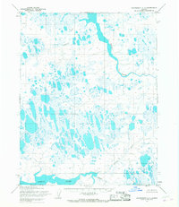
1955 Map of Wainwright C-1
USGS Topo · Published 1967About this map
Naval Petroleum Reserve No. 4 encompasses this entire Arctic expanse, which was mapped in the mid-1950s using photogrammetric methods from aerial photographs. The landscape is dominated by a complex network of thaw lakes and braided water systems, defined primarily by the Kugrua River flowing through the northeastern section and the wide reaches of the Kungok River to the south. Avgumun Creek meanders through the central northern tundra, while the feature known as Kolipsun stands as a rare named landmark in this otherwise sparse interior. These 1955 surveys by the Army Map Service record the hydrography of the North Slope during a period of federal exploration and energy evaluation, capturing the untouched state of the drainage basins before later industrial developments in the region.
Find a feature on this map
9 named features on this map. Tap any name to fly to it.
Don’t see what you’re looking for? This feature index may not catch every label — zoom into the map to look around manually.
Map Details
Editions of this 1955 Wainwright C-1 Map
2 editions found
Other maps of this area

1951 · Meade River
USGS Topo · 1:250,000

1951 · Wainwright
USGS Topo · 1:250,000

1955 · Wainwright
USGS Topo · 1:250,000

1955 · Wainwright B-1
USGS Topo · 1:63,360

1955 · Meade River
USGS Topo · 1:250,000

1955 · Wainwright C-1
USGS Topo · 1:63,360

1955 · Meade River D-5
USGS Topo · 1:63,360

1955 · Meade River C-5
USGS Topo · 1:63,360
1955 · Wainwright D-2
USGS Topo · 1:63,360
1955 · Meade River B-5
USGS Topo · 1:63,360