
1955 Map of Meade River C-5
USGS Topo · Published 1967About this map
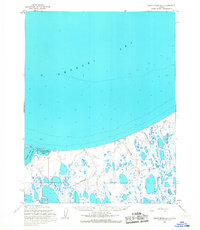
Lake Itinik and Lake Tuvak dominate this expansive landscape on the Arctic coastal plain, where countless unnamed thaw lakes and ponds saturate the tundra. The intricate network of waterways includes the meandering Kugrua River and Kungok River, which flow across the flat terrain. The reliance on seasonal access is evident in the presence of a Winter Trail cutting through the eastern portion of the quadrangle. This 1955 survey, compiled by the Army Map Service, captures the remote character of the North Slope within the Naval Petroleum Reserve No. 4. The distribution of oriented lakes suggests the distinct geomorphological processes of this permafrost-underlain region, where surface water is constrained by the frozen ground below.
Find a feature on this map
5 named features on this map. Tap any name to fly to it.
Don’t see what you’re looking for? This feature index may not catch every label — zoom into the map to look around manually.
Map Details
Editions of this 1955 Meade River C-5 Map
This is the sole edition of this map. No revisions or reprints were ever made.
Other maps of this area

1951 · Meade River
USGS Topo · 1:250,000

1951 · Wainwright
USGS Topo · 1:250,000

1955 · Wainwright
USGS Topo · 1:250,000

1955 · Wainwright B-1
USGS Topo · 1:63,360

1955 · Meade River
USGS Topo · 1:250,000

1955 · Wainwright C-1
USGS Topo · 1:63,360

1955 · Meade River D-5
USGS Topo · 1:63,360

1955 · Meade River B-4
USGS Topo · 1:63,360
1955 · Meade River D-4
USGS Topo · 1:63,360

1955 · Meade River C-4
USGS Topo · 1:63,360