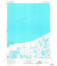
1955 Map of Meade River D-4
USGS Topo · Published 1967About this map
Peard Bay and the vast Chukchi Sea dominate the northern coastline of this Arctic landscape within the Naval Petroleum Reserve No. 4. This 1955 survey illustrates a remote tundra environment defined by an intricate network of lakes, lagoons, and meandering waterways like Kunarak Creek and Papigak Creek. Small, isolated landmarks such as Herbert, Carlotta, and Faun suggest temporary camps or localized survey points in an area largely devoid of permanent infrastructure.
Find a feature on this map
21 named features on this map. Tap any name to fly to it.
Don’t see what you’re looking for? This feature index may not catch every label — zoom into the map to look around manually.
Map Details
Editions of this 1955 Meade River D-4 Map
This is the sole edition of this map. No revisions or reprints were ever made.
Other maps of this area

1951 · Meade River
USGS Topo · 1:250,000

1955 · Meade River
USGS Topo · 1:250,000

1955 · Meade River D-5
USGS Topo · 1:63,360

1955 · Meade River C-5
USGS Topo · 1:63,360

1955 · Meade River C-3
USGS Topo · 1:63,360

1955 · Meade River C-4
USGS Topo · 1:63,360

1955 · Meade River D-3
USGS Topo · 1:63,360
1962 · Meade River C-4
USGS Topo · 1:50,000
1962 · Meade River C-5
USGS Topo · 1:50,000
1962 · Meade River D-3
USGS Topo · 1:50,000