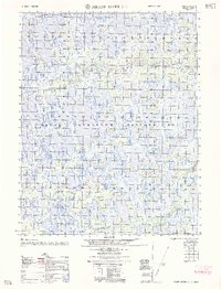
1962 Map of Meade River C-4
USGS Topo · Published 1962About this map
Naval Petroleum Reserve No 4 dominates this Arctic landscape, where a dense network of thaw lakes and ponds defines the permafrost terrain. The Inaru River, also identified by its indigenous name Kuahrook River, meanders across the northern portion of the sheet, reflecting the hydrologic complexity of the North Slope before extensive modern development. A lone Winter Trail provides the only evidence of overland passage through the tundra, likely utilized for seasonal transport when the ground was frozen. In the southern reaches, Kucheak Creek feeds into the intricate water system, illustrating the primitive state of the region's geography as documented by the Army Map Service in the mid-1950s. This survey captures a moment when government resource interests and traditional pathways intersected in the Alaskan wilderness.
Find a feature on this map
7 named features on this map. Tap any name to fly to it.
Don’t see what you’re looking for? This feature index may not catch every label — zoom into the map to look around manually.
Map Details
Editions of this 1962 Meade River C-4 Map
This is the sole edition of this map. No revisions or reprints were ever made.
Other maps of this area

1951 · Meade River
USGS Topo · 1:250,000

1955 · Meade River
USGS Topo · 1:250,000

1955 · Meade River B-3
USGS Topo · 1:63,360

1955 · Meade River D-5
USGS Topo · 1:63,360

1955 · Meade River C-5
USGS Topo · 1:63,360

1955 · Meade River C-3
USGS Topo · 1:63,360

1955 · Meade River B-4
USGS Topo · 1:63,360
1955 · Meade River D-4
USGS Topo · 1:63,360

1955 · Meade River C-4
USGS Topo · 1:63,360

1955 · Meade River D-3
USGS Topo · 1:63,360