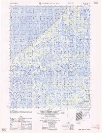
1962 Map of Meade River D-3
USGS Topo · Published 1962About this map
Naval Petroleum Reserve No 4 dominates this 1962 Arctic survey, a period of early energy exploration along the remote North Slope. The landscape is defined by the sharp coastal break of Skull Cliff overlooking the Chukchi Sea, where the Army Map Service recorded the Skull Cliff Test Well No 1 and a nearby Oil seep. These markers signify the industrial transition of the Alaskan wilderness as teams utilized a Tractor Trail to navigate the thaw-lake-studded tundra. Inland, the hydrology is complex, featuring the meandering Inaru River, Niklavik Creek, and Kuahrook River. Small-scale human presence is noted only by isolated landmarks like a Tower and a lone Cabin, highlighting the isolation of the territory during this strategic Cold War-era resource survey.
Find a feature on this map
14 named features on this map. Tap any name to fly to it.
Don’t see what you’re looking for? This feature index may not catch every label — zoom into the map to look around manually.
Map Details
Editions of this 1962 Meade River D-3 Map
This is the sole edition of this map. No revisions or reprints were ever made.
Other maps of this area

1945 · Barrow
USGS Topo · 1:250,000

1949 · Barrow
USGS Topo · 1:250,000

1951 · Meade River
USGS Topo · 1:250,000

1955 · Barrow
USGS Topo · 1:250,000

1955 · Meade River
USGS Topo · 1:250,000

1955 · Barrow A-5
USGS Topo · 1:63,360

1955 · Meade River D-2
USGS Topo · 1:63,360

1955 · Meade River C-3
USGS Topo · 1:63,360
1955 · Meade River D-4
USGS Topo · 1:63,360

1955 · Meade River C-4
USGS Topo · 1:63,360