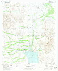
1981 Map of Vaiva Vo
USGS Topo · Published 1981About this map
Vaiva Vo serves as a focal point within the Papago Indian Reservation during the early 1980s, illustrating a landscape defined by significant water management projects in the Sonoran desert. The southern portion of the map is dominated by the Tat Momolikot Dam and the resulting Lake St Clair, which collects the seasonal flows of the Santa Rosa Wash. This infrastructure highlights the transition from traditional desert land use to modern hydrological engineering, contrasting with older settlement markers such as a small Cem and various Ruins located near the village center. To the west and east, the Vaiva Hills and Tat Momoli Mountains hem in the Santa Rosa Valley, where a network of pipelines, an aqueduct, and numerous wells indicate the intensive effort to secure water for this arid territory.
Find a feature on this map
25 named features on this map. Tap any name to fly to it.
Don’t see what you’re looking for? This feature index may not catch every label — zoom into the map to look around manually.
Map Details
Editions of this 1981 Vaiva Vo Map
2 editions found
Other maps of this area

1922 · Casa Grande
USGS Topo · 1:62,500

1924 · Casa Grande
USGS Topo · 1:62,500

1941 · Vekol Mountains
USGS Topo · 1:62,500

1942 · Silver Reef Mountains
USGS Topo · 1:62,500

1942 · Vekol Mountains
USGS Topo · 1:62,500

1946 · Antelope Peak
USGS Topo · 1:62,500

1948 · Antelope Peak
USGS Topo · 1:62,500

1953 · Ajo
USGS Topo · 1:250,000

1956 · Tucson
USGS Topo · 1:250,000

1957 · Ajo
USGS Topo · 1:250,000