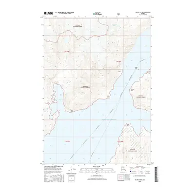
2016 Map of Valdez A-8 SE
USGS Topo · Published 2016About this map
Glacial ice and maritime passage define this coastal Alaskan landscape, where the Westbrook Glacier, Annin Glacier, and Anderson Glacier descend from high peaks toward the sea. The settlement of Valdez occupies the northeastern shore, serving as a critical hub where the Alaska Marine Hwy navigates the deep waters of Port Valdez. This 2016 survey illustrates the dramatic topography of the Chugach National Forest, emphasizing the narrow maritime corridors and prominent headlands like Potato Point and Entrance Point that guard the Valdez Narrows. The map details a complex shoreline of inlets and bays, including Sawmill Bay and Jack Bay, while inland features like Mt Thomas and Devish Lake highlight the transition from sea level to the high-elevation interior typical of the Prince William Sound region.
Find a feature on this map
25 named features on this map. Tap any name to fly to it.
Don’t see what you’re looking for? This feature index may not catch every label — zoom into the map to look around manually.
Map Details
Editions of this 2016 Valdez A-8 SE Map
This is the sole edition of this map. No revisions or reprints were ever made.
Other maps of this area

1948 · Cordova
USGS Topo · 1:250,000

1950 · Cordova D-7
USGS Topo · 1:63,360

1951 · Cordova
USGS Topo · 1:250,000

1951 · Cordova D-8
USGS Topo · 1:63,360

1952 · Valdez
USGS Topo · 1:250,000

1952 · Cordova D-8
USGS Topo · 1:63,360

1952 · Cordova D-7
USGS Topo · 1:63,360

1959 · Cordova
USGS Topo · 1:250,000

1960 · Valdez A-8
USGS Topo · 1:63,360

1960 · Valdez A-7
USGS Topo · 1:63,360