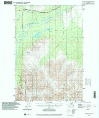
1993 Map of Valdez D-8
USGS Topo · Published 2001About this map
The Little Nelchina River flows through the northern reaches of this region in the Matanuska-Susitna Borough, where the high-altitude terrain is dominated by the massive Heavenly Ridge. Infrastructure is concentrated along the Glenn Highway, which follows the river valley and provides access to a roadside Campground and a Gravel Pit. This 1993 study reflects a landscape defined by dramatic elevation changes and remote water bodies like Twin Lakes and Nelchina Bench Lake. South of the Base Line, the topography becomes increasingly complex as Barnette Creek and Bentley Creek cut through the high country. The presence of a lone Cabin near the center of the sheet suggests the limited and seasonal nature of human activity in this part of the Alaskan interior.
Find a feature on this map
12 named features on this map. Tap any name to fly to it.
Don’t see what you’re looking for? This feature index may not catch every label — zoom into the map to look around manually.
Map Details
Editions of this 1993 Valdez D-8 Map
This is the sole edition of this map. No revisions or reprints were ever made.
Other maps of this area

1948 · Anchorage D-1
USGS Topo · 1:63,360

1949 · Talkeetna Mountains A-1
USGS Topo · 1:63,360

1949 · Gulkana A-6
USGS Topo · 1:63,360

1949 · Valdez D-8
USGS Topo · 1:63,360

1949 · Valdez D-7
USGS Topo · 1:63,360

1950 · Talkeetna Mountains
USGS Topo · 1:250,000

1951 · Gulkana
USGS Topo · 1:250,000

1951 · Valdez D-7
USGS Topo · 1:63,360

1951 · Anchorage
USGS Topo · 1:250,000

1951 · Anchorage D-1
USGS Topo · 1:63,360