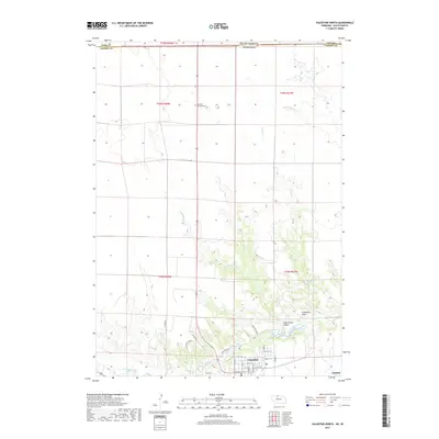
2017 Map of Valentine North
USGS Topo · Published 2017About this map
The northern edge of Valentine meets the South Dakota border in this topographical study of the Nebraska Sandhills transition. The landscape is defined by the incision of Minnechaduza Cr as it flows toward the Mill Pond, carving a complex network of drainages including Government Canyon and Fishberry Cr. On the higher ground north of the breaks, the Richland Harmony Cem stands as a lonely landmark among the section lines of the open range. The map illustrates the striking contrast between the flat tablelands and the sudden, sharp relief of the river valley, where prominent elevations like Frederick Peak and Blue Moon Ridge rise above the surrounding canyons. Water management and conservation are evident in features such as Fish Hatchery Lake and the northern reaches of the Fnnwr wildlife refuge.
Find a feature on this map
36 named features on this map. Tap any name to fly to it.
Don’t see what you’re looking for? This feature index may not catch every label — zoom into the map to look around manually.
Map Details
Editions of this 2017 Valentine North Map
This is the sole edition of this map. No revisions or reprints were ever made.
Other maps of this area

1950 · Sparks
USGS Topo · 1:62,500

1950 · Valentine
USGS Topo · 1:62,500

1955 · Martin
USGS Topo · 1:250,000

1957 · Valentine
USGS Topo · 1:250,000

1958 · Martin
USGS Topo · 1:250,000

1959 · Valentine
USGS Topo · 1:250,000

1969 · Olsonville SW
USGS Topo · 1:24,000

1982 · Olsonville SE
USGS Topo · 1:24,000
1982 · Littleburg
USGS Topo · 1:24,000

1982 · Mission
USGS Topo · 1:100,000