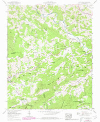
1960 Map of Valle Crucis
USGS Topo · Published 1979About this map
Valle Crucis and the neighboring high-country settlements of Banner Elk and Vilas are captured here during a period of transition, following a series of mid-century updates to this Tennessee Valley Authority and Geological Survey cooperative study. The landscape is defined by the steep transition between the Watauga River valley and the formidable heights of Grandfather Mountain and Beech Mountain. Local genealogy and community life are well-documented through numerous family burial sites and country churches, including the Valle Crucis Mission and Holy Cross Ch near Matney. The map details institutional growth in Banner Elk, anchored by the Grace Hartley Memorial Hospital, while the surrounding terrain remains marked by traditional mountain landmarks such as Hanging Rock, White Rock, and the Blue Ridge Tennessee Valley Divide.
Find a feature on this map
106 named features on this map. Tap any name to fly to it.
Don’t see what you’re looking for? This feature index may not catch every label — zoom into the map to look around manually.
Map Details
Editions of this 1960 Valle Crucis Map
4 editions found
Other maps of this area

1893 · Cranberry
USGS Topo · 1:125,000

1895 · Cranberry
USGS Topo · 1:125,000

1899 · Cranberry
USGS Topo · 1:125,000

1902 · Cranberry
USGS Topo · 1:125,000

1934 · Valle Crucis
USGS Topo · 1:24,000

1934 · Elk Park
USGS Topo · 1:24,000

1934 · Boone
USGS Topo · 1:24,000

1934 · Newland
USGS Topo · 1:24,000

1935 · Doe Mountain
USGS Topo · 1:48,000

1935 · Sherwood
USGS Topo · 1:24,000