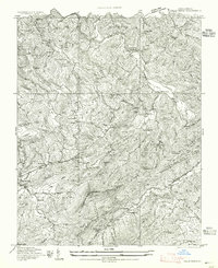
1934 Map of Valle Crucis
USGS Topo · Published 1955About this map
Valle Crucis sits at the confluence of Dutch Creek and the Watauga River, serving as a central hub in these highlands before mid-century modernization. The 1934 surveying reveals a landscape defined by isolated rural communities and religious institutions, including the Valle Crucis Episcopal Ch and several mountain schools like Rominger Sch and Foscoe Sch. A network of gaps and ridges, such as Mast Gap and Bowers Gap, dictate the flow of travel through the peaks of Beech Mountain and Sugar Mtn. Significant topographical features like Hanging Rock and Rocky Face overlook the scattered homesteads of Matney and Rominger, while State Highway 194 winds through the difficult terrain to connect Vilas and Banner Elk. The map also identifies local burial sites and parish centers, such as Estes Cemetery and Salem Ch, which anchor the ancestral geography of the Watauga and Avery county line.
Find a feature on this map
42 named features on this map. Tap any name to fly to it.
Don’t see what you’re looking for? This feature index may not catch every label — zoom into the map to look around manually.
Map Details
Editions of this 1934 Valle Crucis Map
2 editions found
Other maps of this area

1893 · Cranberry
USGS Topo · 1:125,000

1895 · Cranberry
USGS Topo · 1:125,000

1899 · Cranberry
USGS Topo · 1:125,000

1902 · Cranberry
USGS Topo · 1:125,000

1934 · Valle Crucis
USGS Topo · 1:24,000

1934 · Elk Park
USGS Topo · 1:24,000

1934 · Boone
USGS Topo · 1:24,000

1934 · Newland
USGS Topo · 1:24,000

1935 · Doe Mountain
USGS Topo · 1:48,000

1935 · Sherwood
USGS Topo · 1:24,000