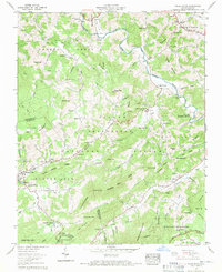
1960 Map of Valle Crucis
USGS Topo · Published 1971About this map
The Tennessee Valley Divide snakes across this terrain, marking a significant hydrologic boundary where waters part toward the Watauga River or the Linville Creek system. This 1960s-era landscape is defined by its deep community roots, centered on the Valle Crucis settlement and its historic Valle Crucis Mission. The map reveals a dense network of family-named landmarks and institutions, from the Grace Hartley Memorial Hospital in Banner Elk to small rural sanctuaries like St Johns Ch and Holy Cross Ch. Large tracts of protected land, including the Pisgah National Forest and Julian Price Memorial Park, dominate the southern reaches, preserving the slopes around Grandfather Mountain and Sugar Mountain. Local history is preserved in numerous family burial grounds such as Baird Cem, Mast Cem, and Shull Cem, which dot the ridges and valleys near Vilas and Matney.
Find a feature on this map
84 named features on this map. Tap any name to fly to it.
Don’t see what you’re looking for? This feature index may not catch every label — zoom into the map to look around manually.
Map Details
Editions of this 1960 Valle Crucis Map
4 editions found
Other maps of this area

1893 · Cranberry
USGS Topo · 1:125,000

1895 · Cranberry
USGS Topo · 1:125,000

1899 · Cranberry
USGS Topo · 1:125,000

1902 · Cranberry
USGS Topo · 1:125,000

1934 · Valle Crucis
USGS Topo · 1:24,000

1934 · Elk Park
USGS Topo · 1:24,000

1934 · Boone
USGS Topo · 1:24,000

1934 · Newland
USGS Topo · 1:24,000

1935 · Doe Mountain
USGS Topo · 1:48,000

1935 · Sherwood
USGS Topo · 1:24,000