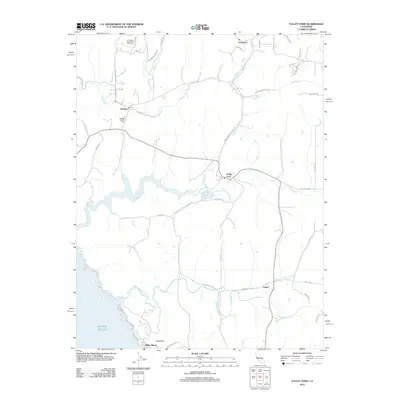
2012 Map of Valley Ford
USGS Topo · Published 2012About this map
Estero Americano and the winding Estero de San Antonio dominate this coastal landscape, tracing deep inlets from the Pacific Ocean into the rolling hills of Marin and Sonoma counties. The area is characterized by a sparse, rural settlement pattern connected by historic corridors like the Bodega Hwy and Valley Ford Rd. In the north, Bodega serves as a central point near the Bodega Calvary Cem and the Joy Woods Redwood Tree Farm, while the village of Valley Ford sits at a narrow crossing of the estero. The southern portion of the map transitions to the coastal community of Dillon Beach near Sugarloaf, where the land meets the sea. This 2012 survey illustrates the enduring agricultural and ranching character of the region, marked by numerous named ranch roads and drainages such as Salmon Cr and Stemple Cr that have defined local property lines and commerce for generations.
Find a feature on this map
48 named features on this map. Tap any name to fly to it.
Don’t see what you’re looking for? This feature index may not catch every label — zoom into the map to look around manually.
Map Details
Editions of this 2012 Valley Ford Map
This is the sole edition of this map. No revisions or reprints were ever made.
Other maps of this area

1916 · Point Reyes
USGS Topo · 1:48,000

1918 · Point Reyes
USGS Topo · 1:62,500

1935 · Sebastopol
USGS Topo · 1:48,000

1942 · Sebastopol
USGS Topo · 1:62,500

1942 · Bodega Head
USGS Topo · 1:24,000

1943 · Duncans Mills
USGS Topo · 1:24,000

1944 · Bodega Head
USGS Topo · 1:31,680
1945 · Duncans Mills
USGS Topo · 1:31,680

1947 · Santa Rosa
USGS Topo · 1:250,000

1949 · Santa Rosa
USGS Topo · 1:250,000