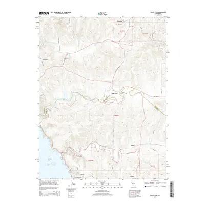
2015 Map of Valley Ford
USGS Topo · Published 2015About this map
Freestone and Valley Ford anchor this coastal landscape where the Sonoma Co and Marin Co line meets the Pacific Ocean. The geography is defined by the winding paths of Estero Americano and Estero de San Antonio, which drain toward Bodega Bay. For those tracing local history, the map identifies the Bodega Calvary Cemetery and the notable San Andreas Fault line running parallel to the shore. Coastal settlements like Dillon Beach and the inland hamlets of Fallon and Tomales are connected by a network of rural routes, including Valley Ford Freestone Rd and Dillon Beach Rd. The terrain rises from the marshy esteros to landmarks such as Whitaker Bluff and Sugarloaf, illustrating the transition from sea-level waterways to the upland drainage of Salmon Cr.
Find a feature on this map
51 named features on this map. Tap any name to fly to it.
Don’t see what you’re looking for? This feature index may not catch every label — zoom into the map to look around manually.
Map Details
Editions of this 2015 Valley Ford Map
This is the sole edition of this map. No revisions or reprints were ever made.
Other maps of this area

1916 · Point Reyes
USGS Topo · 1:48,000

1918 · Point Reyes
USGS Topo · 1:62,500

1935 · Sebastopol
USGS Topo · 1:48,000

1942 · Sebastopol
USGS Topo · 1:62,500

1942 · Bodega Head
USGS Topo · 1:24,000

1943 · Duncans Mills
USGS Topo · 1:24,000

1944 · Bodega Head
USGS Topo · 1:31,680
1945 · Duncans Mills
USGS Topo · 1:31,680

1947 · Santa Rosa
USGS Topo · 1:250,000

1949 · Santa Rosa
USGS Topo · 1:250,000