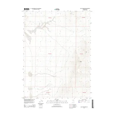
2014 Map of Valley Mountain
USGS Topo · Published 2014About this map
Valley Mountain rises as the central topographic feature in this high-altitude section of Elko County, Nevada. The landscape is defined by the drainages of Drakes Cr, which winds through the eastern canyons beneath the shadow of Lone Butte. This 2014 survey documents the remote high-desert terrain through a precise grid of township and range lines, including t31n r62e and t32n r61e. The map serves as a detailed record of the physical geography of the Great Basin, capturing the intricate contours of the ridges and dry washes that characterize this sparsely populated region of northeastern Nevada.
Find a feature on this map
9 named features on this map. Tap any name to fly to it.
Don’t see what you’re looking for? This feature index may not catch every label — zoom into the map to look around manually.
Map Details
Editions of this 2014 Valley Mountain Map
This is the sole edition of this map. No revisions or reprints were ever made.
Other maps of this area

1935 · Halleck
USGS Topo · 1:125,000

1953 · Spruce Mountain
USGS Topo · 1:62,500

1955 · Elko
USGS Topo · 1:250,000

1958 · Elko
USGS Topo · 1:250,000

1962 · Elko
USGS Topo · 1:250,000

1965 · Elko
USGS Topo · 1:250,000
1984 · Arizona Spring
USGS Topo · 1:24,000
1984 · Ruby City Creek
USGS Topo · 1:24,000

1984 · West of Delcer Buttes
USGS Topo · 1:24,000

1984 · Valley Mtn
USGS Topo · 1:24,000