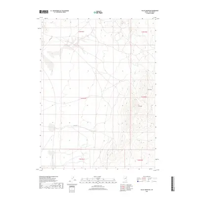
2018 Map of Valley Mountain
USGS Topo · Published 2018About this map
Valley Mtn and the solitary peak of Lone Butte define the eastern high ground of this Elko County landscape, looking out over the expansive drainage of Butte Valley. The terrain is characterized by the complex drainage patterns of Drakes Cr, which winds through the foothills where the mountains meet the basin floor. This 2018 survey documents the precise Public Land Survey System township and range divisions, including t31n r62e and t32n r61e, which are essential for identifying historical land patents and grazing allotments in this part of Nevada. The map illustrates the sparse, high-desert water network typical of the Great Basin, where intermittent streams like Drakes Cr serve as vital markers for both historical navigation and modern land management.
Find a feature on this map
10 named features on this map. Tap any name to fly to it.
Don’t see what you’re looking for? This feature index may not catch every label — zoom into the map to look around manually.
Map Details
Editions of this 2018 Valley Mountain Map
This is the sole edition of this map. No revisions or reprints were ever made.
Other maps of this area

1935 · Halleck
USGS Topo · 1:125,000

1953 · Spruce Mountain
USGS Topo · 1:62,500

1955 · Elko
USGS Topo · 1:250,000

1958 · Elko
USGS Topo · 1:250,000

1962 · Elko
USGS Topo · 1:250,000

1965 · Elko
USGS Topo · 1:250,000
1984 · Arizona Spring
USGS Topo · 1:24,000
1984 · Ruby City Creek
USGS Topo · 1:24,000

1984 · West of Delcer Buttes
USGS Topo · 1:24,000

1984 · Valley Mtn
USGS Topo · 1:24,000