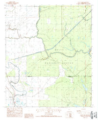
1988 Map of Valley Park
USGS Topo · Published 1988About this map
Valley Park sits at the southern edge of a complex hydraulic landscape where the Delta National Forest meets the winding path of Deer Creek. The area is defined by a dense network of water management features and natural bayous, including the Long Bayou-Greentree Reservoir and the Little Sunflower River. This 1980s-era geography shows a terrain shaped by the proximity of the Mississippi Delta's alluvial patterns, where ancient river bends like False River and human-engineered segments like the Six Mile Cut-Off coexist. The map records the local infrastructure of the period, from the Landing Strip near the river to the distinct boundary line separating Sharkey and Issaquena counties. Local landmarks such as Valley Park Lake and numerous bayous like Ten Mile Bayou highlight a region deeply tied to its wetlands and riverine environment.
Find a feature on this map
16 named features on this map. Tap any name to fly to it.
Don’t see what you’re looking for? This feature index may not catch every label — zoom into the map to look around manually.
Map Details
Editions of this 1988 Valley Park Map
This is the sole edition of this map. No revisions or reprints were ever made.
Other maps of this area

1939 · Onward
USGS Topo · 1:62,500

1939 · Lorenzen
USGS Topo · 1:62,500

1940 · Mechanicsburg
USGS Topo · 1:62,500

1955 · Jackson
USGS Topo · 1:250,000

1961 · Jackson
USGS Topo · 1:250,000

1961 · Bayland
USGS Topo · 1:62,500

1962 · Jackson
USGS Topo · 1:250,000

1963 · Mechanicsburg
USGS Topo · 1:62,500

1963 · Onward
USGS Topo · 1:62,500

1964 · Lorenzen
USGS Topo · 1:62,500