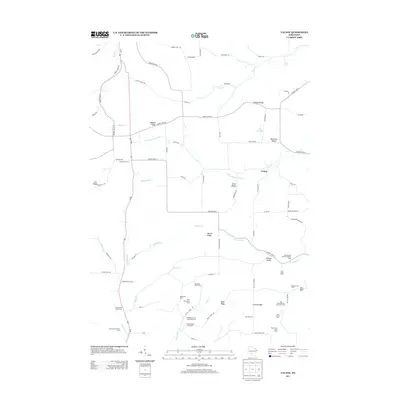
2013 Map of Valton
USGS Topo · Published 2013About this map
Agricultural operations and namesake valleys define this corner of the Driftless Area during the early 21st century. The Little Baraboo River and its many tributaries, such as Beaver Cr and Melancthon Cr, carve a landscape of high ground including Debello Ridge and Hickory Ridge. This map is particularly valuable for its preservation of historic farm names, which persist alongside modern infrastructure like Wi-80. Unlike many modern surveys that omit individual property identities, this record explicitly identifies specialized dairy and stock operations like the Spring Brook Stock and Dairy Farm and the Slaney Home Stock Farm. These labels provide a rare look at the enduring legacy of Wisconsin's dairy industry in rural settlements like Valton and Benders Corners, showing how family-named landmarks like Jones Valley and Grimes Valley remain tied to the physical geography.
Find a feature on this map
85 named features on this map. Tap any name to fly to it.
Don’t see what you’re looking for? This feature index may not catch every label — zoom into the map to look around manually.
Map Details
Editions of this 2013 Valton Map
This is the sole edition of this map. No revisions or reprints were ever made.
Other maps of this area

1905 · Richland Center
USGS Topo · 1:125,000

1927 · Hillsboro
USGS Topo · 1:62,500

1956 · Reedsburg
USGS Topo · 1:62,500

1958 · La Crosse
USGS Topo · 1:250,000

1960 · Richland Center
USGS Topo · 1:62,500

1960 · Plain
USGS Topo · 1:62,500

1961 · La Crosse
USGS Topo · 1:250,000

1965 · La Crosse
USGS Topo · 1:250,000

1966 · Hillsboro
USGS Topo · 1:62,500
1975 · Wonewoc
USGS Topo · 1:24,000