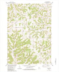
1983 Map of Valton
USGS Topo · Published 1984About this map
Debello Ridge and Marble Ridge define the complex driftless-style topography where Richland, Vernon, and Sauk counties meet. This early 1980s data, revised from mid-century photogrammetry, shows a landscape of narrow ridges and deep valleys like Simpson Hollow and Grimes Valley. The rural character is anchored by small community centers like Valton and the road junction at Benders Corners. Genealogists will find significant value in the mapped religious and burial sites, including St Patricks Ch, Debello Cem, and Greenwood Cem. Small-scale industrial activity is evidenced by several Quarry and Quarries locations scattered along the valley floors, while the Little Baraboo River and Melancthon Creek provide the primary drainage for the surrounding highlands of Greenwood and Henrietta.
Find a feature on this map
55 named features on this map. Tap any name to fly to it.
Don’t see what you’re looking for? This feature index may not catch every label — zoom into the map to look around manually.
Map Details
Editions of this 1983 Valton Map
This is the sole edition of this map. No revisions or reprints were ever made.
Other maps of this area

1905 · Richland Center
USGS Topo · 1:125,000

1927 · Hillsboro
USGS Topo · 1:62,500

1956 · Reedsburg
USGS Topo · 1:62,500

1958 · La Crosse
USGS Topo · 1:250,000

1960 · Richland Center
USGS Topo · 1:62,500

1960 · Plain
USGS Topo · 1:62,500

1961 · La Crosse
USGS Topo · 1:250,000

1965 · La Crosse
USGS Topo · 1:250,000

1966 · Hillsboro
USGS Topo · 1:62,500
1975 · Wonewoc
USGS Topo · 1:24,000