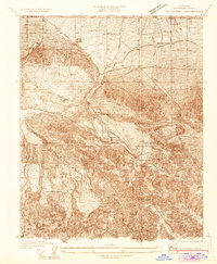
1934 Map of Valyermo
USGS Topo · Published 1934About this map
Valyermo Po serves as a small anchor for this 1934 survey, where the arid floor of the Antelope Valley meets the rising slopes of the Angeles National Forest. The landscape is defined by the geological activity of the St Andrews Rift, which cuts a distinct path through the terrain near the Devil's Punchbowl. This era represents a time of transition for the high desert, as federal work programs are visible via the CCC Camp and forest management at the Big Rock Patrol Sta. Local agriculture and settlement are clustered around water sources like Big Rock Creek, evidenced by numerous family-named properties such as Hughes Ranch, Fenner Ranch, and Burkharts Ranch. These holdings, connected by the Fort Tejon Road and the Llano Cut-off, illustrate a network of remote homesteads surviving on the edge of the desert before modern suburban expansion reached this portion of Los Angeles County.
Find a feature on this map
31 named features on this map. Tap any name to fly to it.
Don’t see what you’re looking for? This feature index may not catch every label — zoom into the map to look around manually.
Map Details
Editions of this 1934 Valyermo Map
This is the sole edition of this map. No revisions or reprints were ever made.
Other maps of this area

1901 · Southern California Sheet No. 1
USGS Topo · 1:250,000

1903 · Rock Creek
USGS Topo · 1:62,500

1904 · Southern California Sheet No. 1
USGS Topo · 1:250,000

1930 · Black Butte
USGS Topo · 1:24,000

1930 · Little Rock
USGS Topo · 1:24,000

1930 · Llano
USGS Topo · 1:24,000

1933 · Black Butte
USGS Topo · 1:24,000
1934 · Little Rock
USGS Topo · 1:24,000

1934 · Mescal Creek
USGS Topo · 1:24,000
1934 · Cima Mesa
USGS Topo · 1:24,000