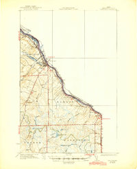
1934 Map of Van Buren
USGS Topo · Published 1945About this map
The St John River forms the international boundary in this 1930s survey, delineating the edge of the United States Canada border. The river valley serves as the primary corridor for settlement and industry, anchored by Van Buren and its neighbor Keegan. The Bangor and Aroostook RR runs parallel to the water, connecting these northern outposts to the rest of the state.
Find a feature on this map
46 named features on this map. Tap any name to fly to it.
Don’t see what you’re looking for? This feature index may not catch every label — zoom into the map to look around manually.
Map Details
Editions of this 1934 Van Buren Map
3 editions found
Other maps of this area

1921 · Van Buren
USGS Topo · 1:250,000

1927 · Stockholm
USGS Topo · 1:48,000

1929 · Caribou
USGS Topo · 1:48,000

1930 · Fort Fairfield
USGS Topo · 1:48,000

1931 · Van Buren
USGS Topo · 1:48,000

1931 · Stockholm
USGS Topo · 1:62,500

1932 · Caribou
USGS Topo · 1:62,500

1933 · Fort Fairfield
USGS Topo · 1:62,500

1934 · Van Buren
USGS Topo · 1:62,500

1938 · Grand Isle
USGS Topo · 1:62,500