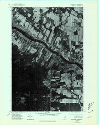
1975 Map of Van Buren SE
USGS Topo · Published 1981About this map
The St John River carves a deep, dark path through the northern landscape of Aroostook County, serving as the international dividing line between the Canada United States border. This orthophotoquad, derived from 1975 aerial photography, reveals the stark contrast between the dense, undeveloped woodlands and the linear patterns of agricultural fields that hug the riverbanks. The settlement of Hamlin sits along this corridor, where the land-use patterns reflect a long history of river-based commerce and farming. On the eastern shore, the boundary between New Brunswick Maine is clearly visible in the transition of field shapes and forest density. This visual record captures the rural character of the borderlands during the mid-1970s, providing a clear view of the roads and farmsteads that defined life in this northern reach of the St. John Valley.
Find a feature on this map
4 named features on this map. Tap any name to fly to it.
Don’t see what you’re looking for? This feature index may not catch every label — zoom into the map to look around manually.
Map Details
Editions of this 1975 Van Buren SE Map
This is the sole edition of this map. No revisions or reprints were ever made.
Other maps of this area

1921 · Van Buren
USGS Topo · 1:250,000

1930 · Fort Fairfield
USGS Topo · 1:48,000

1931 · Van Buren
USGS Topo · 1:48,000

1933 · Fort Fairfield
USGS Topo · 1:62,500

1934 · Van Buren
USGS Topo · 1:62,500

1951 · Van Buren
USGS Topo · 1:62,500

1951 · Fort Fairfield
USGS Topo · 1:62,500

1953 · Fort Fairfield NW
USGS Topo · 1:24,000
1953 · Limestone
USGS Topo · 1:24,000

1959 · Woodstock
USGS Topo · 1:250,000