1971 Map of Van Horne
USGS Topo · Published 1973About this map
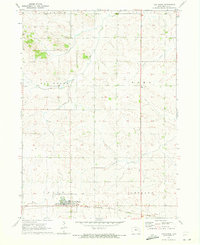
Van Horne sits as the primary settlement on this 1970s survey, surrounded by the gridded agricultural townships of Union, Big Grove, and Eldorado. The town's layout is defined by its proximity to the Chicago Milwaukee St Paul and Pacific rail line, which cuts through the southern portion of the landscape. Outside of the town center, the terrain is shaped by the drainage patterns of Mud Creek, Opossum Creek, and Wildcat Creek, which weave through the rolling fields of Jackson and Taylor townships.
Find a feature on this map
14 named features on this map. Tap any name to fly to it.
Don’t see what you’re looking for? This feature index may not catch every label — zoom into the map to look around manually.
Map Details
Editions of this 1971 Van Horne Map
This is the sole edition of this map. No revisions or reprints were ever made.
Other maps of this area

1888 · Shellsburg
USGS Topo · 1:62,500

1888 · Amana
USGS Topo · 1:62,500

1889 · Amana
USGS Topo · 1:62,500

1889 · Shellsburg
USGS Topo · 1:62,500

1899 · Amana
USGS Topo · 1:62,500

1899 · Shellsburg
USGS Topo · 1:62,500

1903 · Fairfax
USGS Topo · 1:125,000

1903 · Winthrop
USGS Topo · 1:125,000

1954 · Waterloo
USGS Topo · 1:250,000

1954 · Des Moines
USGS Topo · 1:250,000