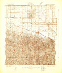
1924 Map of Van Nuys
USGS Topo · Published 1924About this map
San Fernando Valley settlement patterns are captured here during a pivotal decade of expansion, showing the grid-based development of Van Nuys surrounded by expansive agricultural and ranch lands. The map delineates the vast Ex Mission San Fernando grant, where the transition from pastoral use to suburban lots is evident. The transportation network is anchored by the Southern Pacific railroad and the extensive Pacific Electric (Owensmouth Line), which facilitated the valley’s rapid growth by connecting it to the broader Los Angeles basin.
Find a feature on this map
42 named features on this map. Tap any name to fly to it.
Don’t see what you’re looking for? This feature index may not catch every label — zoom into the map to look around manually.
Map Details
Editions of this 1924 Van Nuys Map
This is the sole edition of this map. No revisions or reprints were ever made.
Other maps of this area

1894 · Los Angeles
USGS Topo · 1:62,500

1896 · Santa Monica
USGS Topo · 1:62,500

1898 · Santa Monica
USGS Topo · 1:62,500

1900 · Los Angeles
USGS Topo · 1:62,500

1901 · Southern California Sheet No. 1
USGS Topo · 1:250,000

1902 · Santa Monica
USGS Topo · 1:62,500

1903 · Calabasas
USGS Topo · 1:62,500

1903 · Camulos
USGS Topo · 1:125,000

1904 · Southern California Sheet No. 1
USGS Topo · 1:250,000

1920 · Santa Monica
USGS Topo · 1:62,500