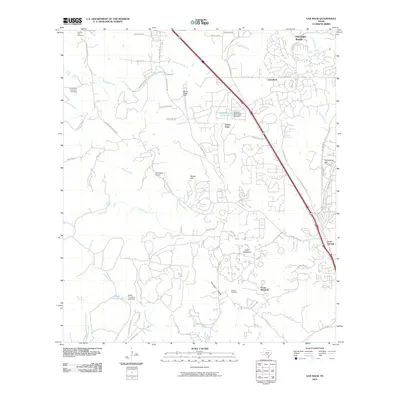
2010 Map of Van Raub
USGS Topo · Published 2010About this map
Fair Oaks Ranch and Scenic Oaks sit at the northern edge of the San Antonio metropolitan reach, where suburban expansion meets the transitional topography of the Texas Hill Country. The landscape is defined by the winding paths of Balcones Creek and Leon Creek, which carve through the limestone terrain toward the Kremkau Divide. Historically significant family markers remain visible through the Charles Cole Cemetery and the Cole And Hugman Cemetery in the northwest, while the Robles Cemetery lies further south near Cross Mountain. Aviation history and local transit are represented by Boerne Stage Field and Tarry Bank Airport, situated near the corridor of Old Fredericksburg Rd. This 2010 survey documents a period of rapid residential platting, visible in the dense street networks of Van Raub contrasted against the larger agricultural holdings and landmarks like McFarland Hill.
Find a feature on this map
64 named features on this map. Tap any name to fly to it.
Don’t see what you’re looking for? This feature index may not catch every label — zoom into the map to look around manually.
Map Details
Editions of this 2010 Van Raub Map
This is the sole edition of this map. No revisions or reprints were ever made.
Other maps of this area

1953 · Otis Ridge
USGS Topo · 1:24,000

1953 · Helotes
USGS Topo · 1:24,000

1953 · Castle Hills
USGS Topo · 1:24,000

1953 · Van Raub
USGS Topo · 1:24,000

1954 · San Antonio
USGS Topo · 1:250,000

1956 · Comfort
USGS Topo · 1:62,500

1956 · Medina Lake
USGS Topo · 1:62,500

1957 · Boerne
USGS Topo · 1:62,500

1957 · San Antonio
USGS Topo · 1:250,000

1964 · Boerne
USGS Topo · 1:24,000