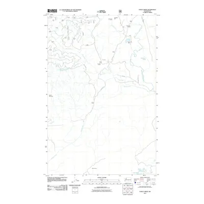
2011 Map of Vance Creek
USGS Topo · Published 2011About this map
The South Fork Skokomish River basin defines this landscape, where industrial history and mountainous terrain intersect. In the north, the High Steel Bridge spans a deep gorge, serving as a landmark for the area's transition from early timber operations to modern forest management. This 2011 survey documents the vestiges of logging infrastructure, including Fir Creek Reload and remote outposts such as Camp 3 and Camp Govey.
Find a feature on this map
33 named features on this map. Tap any name to fly to it.
Don’t see what you’re looking for? This feature index may not catch every label — zoom into the map to look around manually.
Map Details
Editions of this 2011 Vance Creek Map
This is the sole edition of this map. No revisions or reprints were ever made.
Other maps of this area

1939 · Shelton
USGS Topo · 1:62,500

1943 · Potlatch
USGS Topo · 1:62,500

1943 · Nahwatzel Lake
USGS Topo · 1:62,500

1952 · Potlatch
USGS Topo · 1:62,500

1953 · Mt Tebo
USGS Topo · 1:62,500

1953 · Shelton
USGS Topo · 1:62,500

1953 · Elma
USGS Topo · 1:62,500

1958 · Seattle
USGS Topo · 1:250,000

1962 · Seattle
USGS Topo · 1:250,000
1981 · Nahwatzel Lake
USGS Topo · 1:24,000