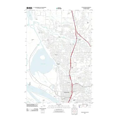
2011 Map of Vancouver
USGS Topo · Published 2011About this map
Vancouver dominates the southern portion of this landscape, its urban grid extending toward the Columbia River and the historical Officers Row district. The 2011 geography reveals a complex network of waterways and wetlands to the west, where Vancouver Lake and the Shillapoo Lake basin define the low-lying terrain near Buckmire Slough. To the north, the suburban expansion reaches into Hazel Dell and Salmon Creek, while the presence of the Clark County Fairgrounds and Robert L Delanoy Airport highlights the region's diverse land use. Genealogists and local historians can trace several burial grounds, including Saint Johns Cemetery and Salmon Creek Cemetery. The transition from industrial waterfront at the Port of Vancouver to the residential character of Lakeshore and Minnehaha illustrates the city's significant northern growth at the start of the 21st century.
Find a feature on this map
112 named features on this map. Tap any name to fly to it.
Don’t see what you’re looking for? This feature index may not catch every label — zoom into the map to look around manually.
Map Details
Editions of this 2011 Vancouver Map
This is the sole edition of this map. No revisions or reprints were ever made.
Other maps of this area

1897 · Portland
USGS Topo · 1:62,500

1905 · Portland
USGS Topo · 1:62,500

1915 · Hillsboro
USGS Topo · 1:62,500

1918 · Hillsboro
USGS Topo · 1:62,500

1922 · St. Helens
USGS Topo · 1:62,500

1940 · Hillsboro
USGS Topo · 1:62,500

1940 · Portland
USGS Topo · 1:62,500

1940 · La Center
USGS Topo · 1:62,500

1941 · St Helens
USGS Topo · 1:62,500

1943 · St Helens
USGS Topo · 1:62,500