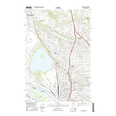
2017 Map of Vancouver
USGS Topo · Published 2017About this map
The Columbia River and the Fort Vancouver National Historic Site define this landscape along the Washington and Oregon border. This modern survey details the urban expansion from the historic center of Vancouver northward into communities like Hazel Dell, Salmon Creek, and Felida. The geography is shaped by water, from the expansive Vancouver Lake and Shillapoo Lake in the west to the winding course of Salmon Creek and Whipple Creek in the north. Significant local heritage is preserved in sites like the Vancouver Barracks Post Cem and the Mother Joseph Catholic Cem. The map illustrates the region's transport and educational infrastructure, including the Burlington Northern Santa Fe RR corridors, the Washington State University Vancouver campus, and the Robert L Delaney Airport. To the northwest, the Ridgefield National Wildlife Refuge marks a preserved natural contrast to the growing suburban landscape.
Find a feature on this map
238 named features on this map. Tap any name to fly to it.
Don’t see what you’re looking for? This feature index may not catch every label — zoom into the map to look around manually.
Map Details
Editions of this 2017 Vancouver Map
This is the sole edition of this map. No revisions or reprints were ever made.
Other maps of this area

1897 · Portland
USGS Topo · 1:62,500

1905 · Portland
USGS Topo · 1:62,500

1915 · Hillsboro
USGS Topo · 1:62,500

1918 · Hillsboro
USGS Topo · 1:62,500

1922 · St. Helens
USGS Topo · 1:62,500

1940 · Hillsboro
USGS Topo · 1:62,500

1940 · Portland
USGS Topo · 1:62,500

1940 · La Center
USGS Topo · 1:62,500

1941 · St Helens
USGS Topo · 1:62,500

1943 · St Helens
USGS Topo · 1:62,500