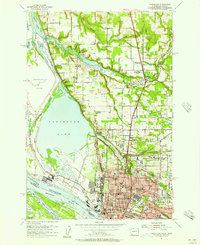
1954 Map of Vancouver
USGS Topo · Published 1957About this map
Vancouver serves as the industrial and historical hub of Clark County, Washington, during this mid-century period. The map highlights the city's complex institutional landscape, featuring specialized facilities such as the Washington Sch for the Blind, Washington Sch for the Deaf, and the notable Providence Academy. Industry is concentrated along the riverfront, anchored by a massive Aluminum Plant and the extensive rail infrastructure of the Northern Pacific and Spokane Portland and Seattle Road.
Find a feature on this map
57 named features on this map. Tap any name to fly to it.
Don’t see what you’re looking for? This feature index may not catch every label — zoom into the map to look around manually.
Map Details
Editions of this 1954 Vancouver Map
This is the sole edition of this map. No revisions or reprints were ever made.
Other maps of this area

1897 · Portland
USGS Topo · 1:62,500

1905 · Portland
USGS Topo · 1:62,500

1915 · Hillsboro
USGS Topo · 1:62,500

1918 · Hillsboro
USGS Topo · 1:62,500

1922 · St. Helens
USGS Topo · 1:62,500

1940 · Hillsboro
USGS Topo · 1:62,500

1940 · Portland
USGS Topo · 1:62,500

1940 · La Center
USGS Topo · 1:62,500

1941 · St Helens
USGS Topo · 1:62,500

1943 · St Helens
USGS Topo · 1:62,500