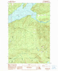
1984 Map of Vanson Peak
USGS Topo · Published 1984About this map
Vanson Peak rises above a landscape defined by the recovery and protection of the Mount St Helens National Volcanic Monument and the Gifford Pinchot National Forest. This 1980s survey captures the area following the 1980 eruption, including a notable zone of blowdown that illustrates the force of the volcanic event. The northern portion of the map is dominated by Riffe Lake, an artificial reservoir on the Cowlitz River, showing an area subject to inundation at the 779-foot contour. Waterways like the Green River, Goat Creek, and Landers Creek carve through the high-elevation terrain, while high mountain features such as Vanson Meadow, Vanson Lake, and Deadmans Lake provide key reference points for those tracing the history of the Washington Cascades. The presence of several borrow pits and a dedicated Pack Trail suggest the ongoing management of this protected wilderness during the early 1980s.
Find a feature on this map
27 named features on this map. Tap any name to fly to it.
Don’t see what you’re looking for? This feature index may not catch every label — zoom into the map to look around manually.
Map Details
Editions of this 1984 Vanson Peak Map
This is the sole edition of this map. No revisions or reprints were ever made.
Other maps of this area

1919 · Mount St Helens
USGS Topo · 1:125,000

1937 · Eatonville
USGS Topo · 1:125,000

1953 · Hoquiam
USGS Topo · 1:250,000

1953 · Elk Rock
USGS Topo · 1:62,500

1956 · Mineral
USGS Topo · 1:62,500

1957 · Hoquiam
USGS Topo · 1:250,000

1957 · Morton
USGS Topo · 1:62,500

1957 · Spirit Lake
USGS Topo · 1:62,500

1958 · Hoquiam
USGS Topo · 1:250,000

1962 · Hoquiam
USGS Topo · 1:250,000