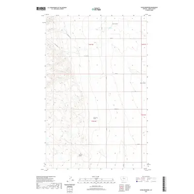
2020 Map of Vaver Reservoir
USGS Topo · Published 2020About this map
Vaver Reservoir and the drainage patterns of northern Liberty County define this high plains landscape. The terrain is deeply incised by a series of north-to-south drainage features, most notably Phillipine Coulee, Fourmile Coulee, and Desert Coulee. These coulees illustrate the erosion-carved topography typical of the Montana borderlands, where seasonal runoff directs the flow toward Scotch Coulee in the north. The area's infrastructure is dominated by a grid of section-line roads and family-named routes such as Dodds-Keith Rd, Little Sage Rd, and Laird Rd. This network facilitates movement across the township and range divisions of t36n r6e and t35n r6e, reflecting the enduring surveyor-grid layout that supports the region's ranching and agricultural operations.
Find a feature on this map
17 named features on this map. Tap any name to fly to it.
Don’t see what you’re looking for? This feature index may not catch every label — zoom into the map to look around manually.
Map Details
Editions of this 2020 Vaver Reservoir Map
This is the sole edition of this map. No revisions or reprints were ever made.
Other maps of this area

1919 · Alma
USGS Topo · 1:125,000

1954 · Shelby
USGS Topo · 1:250,000

1958 · Shelby
USGS Topo · 1:250,000
1962 · Bingham Lake
USGS Topo · 1:24,000

1962 · Lakey Ranch
USGS Topo · 1:24,000

1962 · Mount Lebanon
USGS Topo · 1:24,000

1963 · Bobcat Coulee SE
USGS Topo · 1:24,000

1963 · Vaver Reservoir
USGS Topo · 1:24,000

1963 · Chester NW
USGS Topo · 1:24,000

1963 · Chester NE
USGS Topo · 1:24,000