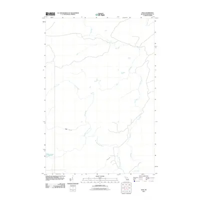
2011 Map of Vega
USGS Topo · Published 2011About this map
Vega stands as the primary named settlement in this pocket of Menominee County, situated near the confluence of Vega Creek and the West Branch Cedar River. The landscape is defined by an intricate network of waterways draining toward the Cedar River, which meanders across the eastern and northern portions of the quadrangle. Smaller tributaries like Labre Creek, Pittsburg Creek, and Spruce Creek carve through the terrain, suggesting a densely wooded or rural character typical of the Upper Peninsula.
Find a feature on this map
10 named features on this map. Tap any name to fly to it.
Don’t see what you’re looking for? This feature index may not catch every label — zoom into the map to look around manually.
Map Details
Editions of this 2011 Vega Map
This is the sole edition of this map. No revisions or reprints were ever made.
Other maps of this area

1954 · Escanaba
USGS Topo · 1:250,000

1956 · Foster City
USGS Topo · 1:62,500

1957 · Escanaba
USGS Topo · 1:250,000

1958 · Escanaba
USGS Topo · 1:250,000

1963 · Bark River
USGS Topo · 1:62,500

1963 · Powers
USGS Topo · 1:62,500

1963 · Schaffer
USGS Topo · 1:62,500

1982 · Escanaba
USGS Topo · 1:100,000
1986 · Waucedah
USGS Topo · 1:24,000
1986 · Vega
USGS Topo · 1:24,000