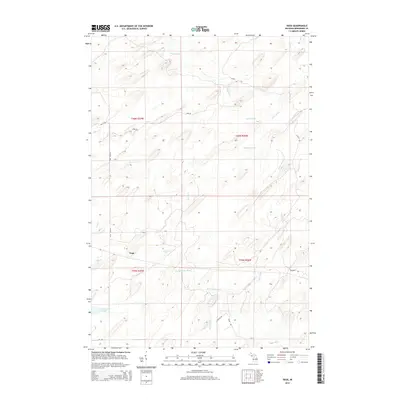
2014 Map of Vega
USGS Topo · Published 2014About this map
The settlement of Vega sits at the heart of this Menominee County landscape, defined by a complex network of waterways in the Upper Peninsula. The drainage pattern is dominated by the Cedar River and its various tributaries, including Nacomis Cr, Labre Creek, and the W Br Cedar River. This 2014 survey captures a rural area where the economy is clearly tied to the land and its timber resources, evidenced by a road network that includes descriptive names like Old Log Rd and Sand Rd, alongside more formal routes such as Vega Road D-1. To the west, Lake Number Eighteen provides a distinct landmark in a terrain otherwise characterized by the winding paths of Spruce Cr and Pittsburg Creek. The map illustrates the contemporary division of the land into townships such as T40N R27W and T39N R26W, showing how modern infrastructure follows these traditional survey lines.
Find a feature on this map
21 named features on this map. Tap any name to fly to it.
Don’t see what you’re looking for? This feature index may not catch every label — zoom into the map to look around manually.
Map Details
Editions of this 2014 Vega Map
This is the sole edition of this map. No revisions or reprints were ever made.
Other maps of this area

1954 · Escanaba
USGS Topo · 1:250,000

1956 · Foster City
USGS Topo · 1:62,500

1957 · Escanaba
USGS Topo · 1:250,000

1958 · Escanaba
USGS Topo · 1:250,000

1963 · Bark River
USGS Topo · 1:62,500

1963 · Powers
USGS Topo · 1:62,500

1963 · Schaffer
USGS Topo · 1:62,500

1982 · Escanaba
USGS Topo · 1:100,000
1986 · Waucedah
USGS Topo · 1:24,000
1986 · Vega
USGS Topo · 1:24,000