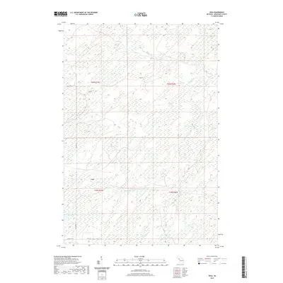
2019 Map of Vega
USGS Topo · Published 2019About this map
Vega stands at the center of this 2019 survey, surrounded by a complex network of wetlands and river systems in Spalding Township. The landscape is defined by the winding course of the Cedar River and its numerous tributaries, including Nacomis Cr, Labre Creek, and Pittsburg Creek. These waterways thread through a densely forested and marshy terrain, illustrated by the extensive green overprint that covers much of the map. In the southern portion of the quadrangle, the drainage pattern becomes more intricate where the W Br Cedar River meets Menard Cr. Human impact is limited to a grid of rural roads such as Sand Rd and Old CC Rd, which navigate around natural features like Lake Number Eighteen. The topographic detail reveals a relatively flat elevation profile typical of the Upper Peninsula, where subtle ridges separate the headwaters of Tenmile Cr and Spruce Cr.
Find a feature on this map
21 named features on this map. Tap any name to fly to it.
Don’t see what you’re looking for? This feature index may not catch every label — zoom into the map to look around manually.
Map Details
Editions of this 2019 Vega Map
This is the sole edition of this map. No revisions or reprints were ever made.
Other maps of this area

1954 · Escanaba
USGS Topo · 1:250,000

1956 · Foster City
USGS Topo · 1:62,500

1957 · Escanaba
USGS Topo · 1:250,000

1958 · Escanaba
USGS Topo · 1:250,000

1963 · Bark River
USGS Topo · 1:62,500

1963 · Powers
USGS Topo · 1:62,500

1963 · Schaffer
USGS Topo · 1:62,500

1982 · Escanaba
USGS Topo · 1:100,000
1986 · Waucedah
USGS Topo · 1:24,000
1986 · Vega
USGS Topo · 1:24,000