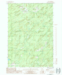
1986 Map of Vega
USGS Topo · Published 1986About this map
The Cedar River and its intricate tributaries dominate this mid-1980s landscape in Michigan's Upper Peninsula, carving through the townships of Spalding and Meyer. The waterway network, including the West Branch Cedar River and smaller flows like Pittsburg Creek and Spruce Creek, defines the drainage patterns of this heavily forested region. While residential settlement is sparse, the map documents active resource extraction through several named Rock Quarry sites situated near Nacomis Creek. Notable for its remote character, the sheet identifies isolated water bodies such as Lake No 18 and seasonal drainage including Tenmile Creek and Labre Creek. This provisional survey captured the area's topographic character just as modern digital mapping techniques were beginning to supplement traditional aerial photography.
Find a feature on this map
15 named features on this map. Tap any name to fly to it.
Don’t see what you’re looking for? This feature index may not catch every label — zoom into the map to look around manually.
Map Details
Editions of this 1986 Vega Map
This is the sole edition of this map. No revisions or reprints were ever made.
Other maps of this area

1954 · Escanaba
USGS Topo · 1:250,000

1956 · Foster City
USGS Topo · 1:62,500

1957 · Escanaba
USGS Topo · 1:250,000

1958 · Escanaba
USGS Topo · 1:250,000

1963 · Bark River
USGS Topo · 1:62,500

1963 · Powers
USGS Topo · 1:62,500

1963 · Schaffer
USGS Topo · 1:62,500

1982 · Escanaba
USGS Topo · 1:100,000
1986 · Waucedah
USGS Topo · 1:24,000
1986 · Helps
USGS Topo · 1:24,000