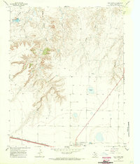
1966 Map of Vega North
USGS Topo · Published 1970About this map
Vega stands at the intersection of the High Plains and the dissected breaks of the Canadian River watershed, as seen in this mid-1960s survey. The town serves as a crucial transit point where the Chicago Rock Island and Pacific railroad parallels the historic path of Route 66, now designated as 66 40. The topography transitions from the flat tableland of the Llano Estacado in the south toward the intricate canyon systems carved by Middle Alamosa Creek and Bradley Fork to the north.
Find a feature on this map
14 named features on this map. Tap any name to fly to it.
Don’t see what you’re looking for? This feature index may not catch every label — zoom into the map to look around manually.
Map Details
Editions of this 1966 Vega North Map
This is the sole edition of this map. No revisions or reprints were ever made.
Other maps of this area

1954 · Tucumcari
USGS Topo · 1:250,000

1958 · Tucumcari
USGS Topo · 1:250,000

1965 · Everett
USGS Topo · 1:24,000

1966 · Alamocitos Camp
USGS Topo · 1:24,000

1966 · Simms NE
USGS Topo · 1:24,000

1966 · Jay Taylor Ranch
USGS Topo · 1:24,000

1966 · Halfway Creek
USGS Topo · 1:24,000

1966 · Landergin
USGS Topo · 1:24,000

1966 · Vega South
USGS Topo · 1:24,000

1966 · Torrea Peak
USGS Topo · 1:24,000