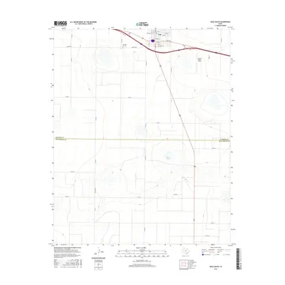
2016 Map of Vega South
USGS Topo · Published 2016About this map
Vega serves as the focal point of this Panhandle landscape, positioned at the intersection of major transport corridors in the high plains. The town's grid is well-defined, featuring streets such as Vega Blvd and Coke St that lead toward the surrounding agricultural expanse. Beyond the residential center, the landscape is marked by the presence of the Oldham County Airport and the Memorial Park Cem, reflecting the community's local infrastructure and history. Moving south across the boundary between Oldham Co and Deaf Smith Co, the terrain becomes more defined by natural depressions and isolated water bodies like Dodson Lake. This area showcases the transition from a structured townsite to the wide-open ranching and farming country typical of the region, where a network of county roads like Granada Rd and Cemetery Rd provide the primary connections across the flat terrain.
Find a feature on this map
32 named features on this map. Tap any name to fly to it.
Don’t see what you’re looking for? This feature index may not catch every label — zoom into the map to look around manually.
Map Details
Editions of this 2016 Vega South Map
This is the sole edition of this map. No revisions or reprints were ever made.
Other maps of this area

1954 · Tucumcari
USGS Topo · 1:250,000

1958 · Tucumcari
USGS Topo · 1:250,000

1965 · Everett
USGS Topo · 1:24,000

1965 · Allison Ranch
USGS Topo · 1:24,000

1966 · Overstreet Lake
USGS Topo · 1:24,000

1966 · Simms NE
USGS Topo · 1:24,000

1966 · Jay Taylor Ranch
USGS Topo · 1:24,000

1966 · Landergin
USGS Topo · 1:24,000

1966 · Vega South
USGS Topo · 1:24,000

1966 · Ford
USGS Topo · 1:24,000