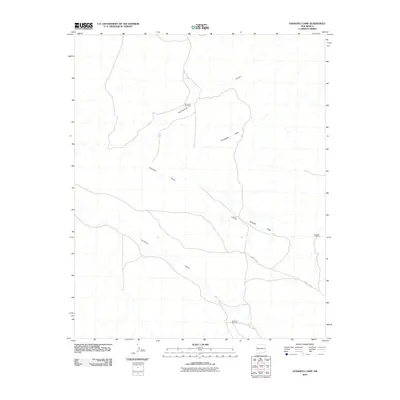
2010 Map of Venadito Camp
USGS Topo · Published 2010About this map
Venadito Camp sits as a central point of reference in this arid reach of New Mexico, where the landscape is defined by the convergence of ephemeral drainages. The area is characterized by a network of seasonal watercourses, including Venadito Draw and Jaralosa Draw, which have carved subtle paths through the high-desert terrain. Evidence of ranching and land management is sparse but significant, marked by the strategic placement of water sources such as Windmill Number 9, Venadito Windmill, and Sandoval Windmill. Modern transit across this portion of Cibola County is primarily facilitated by County Rd 32, which traverses the southern half of the sheet. The layout of these windmills and the naming of specific draws like Yellowrock Draw and Thompson Draw provide a clear view of how water resources dictate human activity in this environment.
Find a feature on this map
10 named features on this map. Tap any name to fly to it.
Don’t see what you’re looking for? This feature index may not catch every label — zoom into the map to look around manually.
Map Details
Editions of this 2010 Venadito Camp Map
This is the sole edition of this map. No revisions or reprints were ever made.
Other maps of this area

1886 · St Johns
USGS Topo · 1:250,000

1892 · St Johns
USGS Topo · 1:250,000

1954 · Saint Johns
USGS Topo · 1:250,000

1957 · Saint Johns
USGS Topo · 1:250,000

1958 · Saint Johns
USGS Topo · 1:250,000

1962 · Saint Johns
USGS Topo · 1:250,000
1972 · Plumasano Basin
USGS Topo · 1:24,000

1972 · Cantaralo Spring
USGS Topo · 1:24,000
1972 · Ojo Caliente Reservoir
USGS Topo · 1:24,000
1972 · Atarque Lake
USGS Topo · 1:24,000