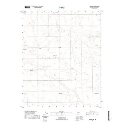
2020 Map of Venadito Camp
USGS Topo · Published 2020About this map
Venadito Camp serves as the primary named site within this high-desert landscape in Cibola County, where the topography is defined by a network of drainage features. The terrain is marked by seasonal watercourses and deep incisions such as Thompson Draw, which spans several sections, and the prominent Yellowrock Canyon. Further south, Venadito Draw and Jaralosa Draw dictate the local relief, illustrating the natural erosion patterns of the region. Transportation is limited to a few corridor routes, most notably Co Rd 32, which provides access through the southeastern portion of the quadrangle. The map highlights the vastness of the Public Land Survey System divisions, with the area categorized under several townships and ranges, indicating a territory primarily structured around large-scale land management and ranching operations.
Find a feature on this map
15 named features on this map. Tap any name to fly to it.
Don’t see what you’re looking for? This feature index may not catch every label — zoom into the map to look around manually.
Map Details
Editions of this 2020 Venadito Camp Map
This is the sole edition of this map. No revisions or reprints were ever made.
Other maps of this area

1886 · St Johns
USGS Topo · 1:250,000

1892 · St Johns
USGS Topo · 1:250,000

1954 · Saint Johns
USGS Topo · 1:250,000

1957 · Saint Johns
USGS Topo · 1:250,000

1958 · Saint Johns
USGS Topo · 1:250,000

1962 · Saint Johns
USGS Topo · 1:250,000
1972 · Plumasano Basin
USGS Topo · 1:24,000

1972 · Cantaralo Spring
USGS Topo · 1:24,000
1972 · Ojo Caliente Reservoir
USGS Topo · 1:24,000
1972 · Atarque Lake
USGS Topo · 1:24,000