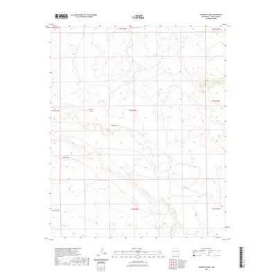
2023 Map of Venadito Camp
USGS Topo · Published 2023About this map
Yellowrock Canyon and the surrounding drainage basins define this portion of the New Mexico landscape within Cibola County. This 2023 survey illustrates a high-desert environment characterized by its complex network of ephemeral waterways, including Thompson Draw and Jaralosa Draw, which carve through the terrain. The map provides a contemporary view of the region's infrastructure, notably the presence of Indian Svc Rte 33 in the northern sections and Co Rd 32 to the southeast. These routes, alongside numerous unnamed local roads and trails, suggest a landscape primarily utilized for ranching or land management rather than dense settlement. The precise delineation of township and range boundaries, such as t7n r20w, reveals the enduring structure of the Public Land Survey System in organizing this sparsely populated territory.
Find a feature on this map
14 named features on this map. Tap any name to fly to it.
Don’t see what you’re looking for? This feature index may not catch every label — zoom into the map to look around manually.
Map Details
Editions of this 2023 Venadito Camp Map
This is the sole edition of this map. No revisions or reprints were ever made.
Other maps of this area

1886 · St Johns
USGS Topo · 1:250,000

1892 · St Johns
USGS Topo · 1:250,000

1954 · Saint Johns
USGS Topo · 1:250,000

1957 · Saint Johns
USGS Topo · 1:250,000

1958 · Saint Johns
USGS Topo · 1:250,000

1962 · Saint Johns
USGS Topo · 1:250,000
1972 · Plumasano Basin
USGS Topo · 1:24,000

1972 · Cantaralo Spring
USGS Topo · 1:24,000
1972 · Ojo Caliente Reservoir
USGS Topo · 1:24,000
1972 · Atarque Lake
USGS Topo · 1:24,000