
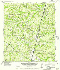
1980 Map of Venado Creek East
USGS Topo · Published 1980About this map
Venado Creek and its southern tributaries wind through this corner of Webb County, defining a landscape of intermittent drainage and scattered stock tanks. Surveyed in the mid-1970s, the map reveals a ranching environment where water management is central to the land's utility. Dolores Creek and Los Olmos Creek converge in the north, while the winding path of Carrizitos Creek crosses the western plains. The presence of a prominent Pipeline cutting across the terrain and the high-elevation point at Becerra underscore the industrial and topographical markers that define this South Texas brush country. This survey serves as a precise record of rural land divisions and water infrastructure before subsequent decades of regional development.
Find a feature on this map
7 named features on this map. Tap any name to fly to it.
Don’t see what you’re looking for? This feature index may not catch every label — zoom into the map to look around manually.
Map Details
Editions of this 1980 Venado Creek East Map
This is the sole edition of this map. No revisions or reprints were ever made.
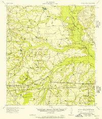
Other maps of this area

1929 · Cotulla
USGS Topo · 1:125,000

1953 · Crystal City
USGS Topo · 1:250,000

1955 · Crystal City
USGS Topo · 1:250,000

1956 · Becerra
USGS Topo · 1:62,500

1956 · Webb
USGS Topo · 1:62,500

1956 · Laredo
USGS Topo · 1:250,000
1957 · Encinal
USGS Topo · 1:62,500
1957 · Caiman Creek
USGS Topo · 1:62,500

1961 · Crystal City
USGS Topo · 1:250,000

1968 · Crystal City
USGS Topo · 1:250,000